Plaetje:Kingdom of Prussia 1870.svg

Aafmaetinge van dees veurbesjoewing van 't type PNG van dit SVG-bestandj: 450 × 456 pixels Anger resoluties: 237 × 240 pixels | 474 × 480 pixels | 758 × 768 pixels | 1.011 × 1.024 pixels | 2.021 × 2.048 pixels.
Oearsprunkelik bestandj (SVG-bestandj, nominaal 450 × 456 pixels, bestandsgruutde: 705 kB)
Besjrieving
Deze niet W3C-verklaarde vectorafbeelding is gemaakt met Inkscape .


.svg)
.svg)
.svg)
.svg)
.svg)


.svg)
.svg)
.svg)


.png)
.png)


.svg)


.svg)

.svg)


.svg)
.svg)
.svg)
.svg)


.svg)
.png)


.svg)


.svg)
.svg)


.svg)


.svg)


.svg)
.svg)
.svg)
.svg)
.svg)
.svg)
.svg)
_cropped.svg)
.svg)
.svg)
.svg)
.svg)
.svg)
.svg)
.svg)
.svg)
.svg)
.svg)
.svg)
.svg)
.svg)
.svg)
.svg)
.svg)
.svg)
.svg)
.svg)
.svg)
.svg)
.svg)
.svg)
.svg)
.svg)
.svg)
.svg)
.svg)
.svg)
.svg)
.svg)
.svg)
.svg)
.svg)
.svg)
.svg)
.svg)
.svg)
.svg)
.svg)
.svg)
.svg)
.svg)
.svg)
.svg)
Licentie:
Dit bestand is gelicenseerd onder de Creative Commons Naamsvermelding-GelijkDelen 4.0 Internationaal licentie.
- De maags:
- deile – aafsjrieve, verspreie en dórchgaeve
- hèrminge – 't wèrk aanpasje
- Óngere volgendje veurwaerj:
- Attribuusje – Geer mótj op 'n gepasdje meneer 'n naamsvermeljing make, 'ne link nao de licentie opgaeve, en aangaeve of g'r 't werk verangerd höb. Geer moog dit op eder raejelike meneer doon, meh neet zoea det 't liek ofwen de licentiegaever instump mit eur werk of eur gebroek van zie werk.
- Deil gliek – Went geer dit werk geremix, verangerd of doorverwirk höb, mótj geer 't verangerd matterjaal verspreie ónger dezelfde licentie wie 't oersjprunkelik werk, of 'n licentie die daomit samegeit.
Besjtandjshistorie
Klik op 'ne datum/tied om 't besjtand te zeen wie 't destieds waor.
| Datum/tied | Miniatuurplaetje | Aafmaetinge | Gebroeker | Opmirking | |
|---|---|---|---|---|---|
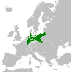
| hujig | 1 jun 2016 04:54 | | 450 × 456 (705 kB) | Alphathon | Various corrections to the states of the North German Confederation |
| 31 mei 2016 07:22 |  | 450 × 456 (662 kB) | Alphathon | Minor corrections (Tarasp and post-1818 German Confederation border change) | |
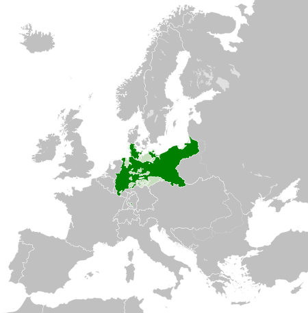
| 31 mei 2016 04:40 |  | 450 × 456 (662 kB) | Alphathon | == {{int:filedesc}} == {{Inkscape}} {{Information |Description={{en|A map of the en:Kingdom of Prussia within the North German Confederation and within Europe circa 1870 CE.}} |Source= {{Derived from|Blank_map_of_Europe.svg|display=50}} |Da... |
Bestandjsbroek
Dit besjtandj weurt op de volgende pagina gebroek:
Globaal besjtandjsgebroek
De volgende anger wiki's gebroeke dit bestandj:
- Gebroek in af.wiktionary.org
- Gebroek in ar.wikipedia.org
- Gebroek in bn.wikipedia.org
- Gebroek in ckb.wikipedia.org
- Gebroek in en.wikipedia.org
- Gebroek in eo.wiktionary.org
- Gebroek in es.wikipedia.org
- Gebroek in es.wiktionary.org
- Gebroek in eu.wikipedia.org
- Gebroek in fa.wikipedia.org
- Gebroek in fi.wikipedia.org
- Gebroek in he.wikipedia.org
- Gebroek in hu.wikipedia.org
- Gebroek in is.wikipedia.org
- Gebroek in it.wikipedia.org
- Gebroek in lld.wikipedia.org
- Gebroek in lt.wikipedia.org
- Gebroek in mn.wikipedia.org
- Gebroek in pl.wikipedia.org
- Gebroek in rue.wikipedia.org
- Gebroek in ru.wikipedia.org
- Gebroek in ru.wiktionary.org
- Gebroek in sk.wikipedia.org
- Gebroek in szl.wikipedia.org
- Gebroek in tr.wikipedia.org
- Gebroek in uk.wikipedia.org
- Gebroek in uz.wikipedia.org
- Gebroek in xmf.wikipedia.org
- Gebroek in zh.wikipedia.org