Plaetje:Antarctica (3), Adelaide Island, Wormald Ice Piedmont.JPG
Gruutde van dees veurvertuining: 800 × 531 pixels. Anger resoluties: 320 × 213 pixels | 640 × 425 pixels | 1.024 × 680 pixels | 1.280 × 850 pixels | 1.716 × 1.140 pixels.
Oearsprunkelik bestandj (1.716 × 1.140 pixels, besjtandjgruutde: 408 kB, MIME-type: image/jpeg)
,_Adelaide_Island,_Wormald_Ice_Piedmont.JPG)
Besjrieving
| Besjrieving |
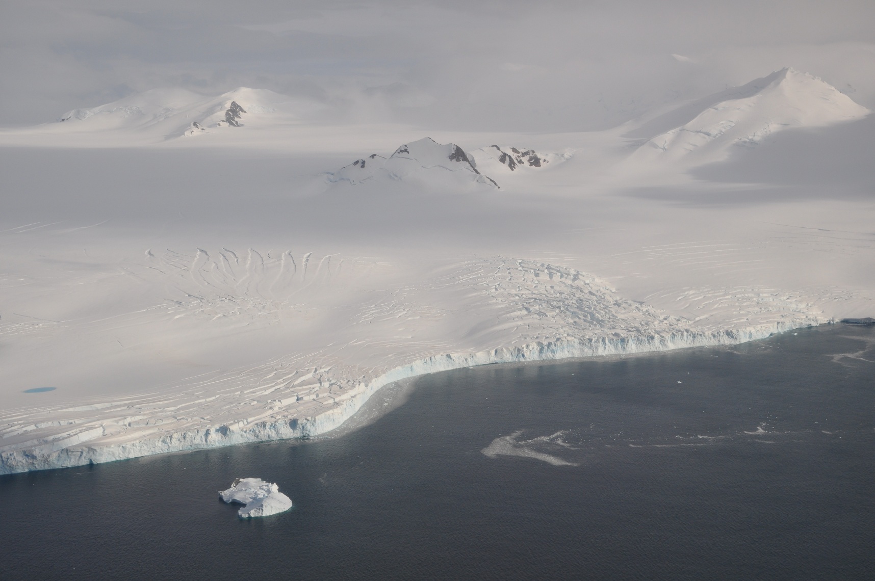
English: The Wormald Ice Piedmont covers large parts of the Wright Peninsula on eastern Adelaide Island, Antarctica, and terminates in high ice cliffs on Laubeuf Fjord. The nunatak in the centre of the picture has a height of 398 m. The mountains on the right form part of the Stokes Peaks and mark the northern edge of the ice piedmont. On the far left a melting pond can be seen on the ice. Viewing direction is toward the NNW. |
| Datum | |
| Brón | Eige werk |
| Sjriever | Vincent van Zeijst |
•
| Cameralocatie | | Deze en andere afbeeldingen in: OpenStreetMap |
|---|
,_Adelaide_Island,_Wormald_Ice_Piedmont.JPG¶ms=-67.500686_N_-068.010864_E_globe:Earth_type:camera_heading:337.50&language=li)
Licentie:
Ich, de copyrighthauwer van dit wirk, maak 't hiebie ónger óngerstaonde licentie besjikbaar:
Dit bestandj steit gelicenseerdj óngere Creative Commons Attribution-Share Alike 3.0 Unported lisensje.
- De maags:
- deile – aafsjrieve, verspreie en dórchgaeve
- hèrminge – 't wèrk aanpasje
- Óngere volgendje veurwaerj:
- Attribuusje – Geer mótj op 'n gepasdje meneer 'n naamsvermeljing make, 'ne link nao de licentie opgaeve, en aangaeve of g'r 't werk verangerd höb. Geer moog dit op eder raejelike meneer doon, meh neet zoea det 't liek ofwen de licentiegaever instump mit eur werk of eur gebroek van zie werk.
- Deil gliek – Went geer dit werk geremix, verangerd of doorverwirk höb, mótj geer 't verangerd matterjaal verspreie ónger dezelfde licentie wie 't oersjprunkelik werk, of 'n licentie die daomit samegeit.
Besjtandjshistorie
Klik op 'ne datum/tied om 't besjtand te zeen wie 't destieds waor.
| Datum/tied | Miniatuurplaetje | Aafmaetinge | Gebroeker | Opmirking | |
|---|---|---|---|---|---|
| hujig | 8 mie 2011 23:48 | | 1.716 × 1.140 (408 kB) | Loranchet | {{Information |Description ={{en|1=The Wormald Ice Piedmont covers large parts of the Wright Peninsula on eastern Adelaide Island, Antarctica, and terminates in high ice cliffs on Laubeuf Fjord. The nunatak in the centre of the picture has a height of |
Bestandjsbroek
Dit besjtandj weurt op de volgende pagina gebroek:
Globaal besjtandjsgebroek
De volgende anger wiki's gebroeke dit bestandj:
- Gebroek in azb.wikipedia.org
- Gebroek in ceb.wikipedia.org
- Gebroek in de.wikipedia.org
- Gebroek in de.wiktionary.org
- Gebroek in en.wikipedia.org
- Gebroek in fi.wikipedia.org
- Gebroek in he.wikipedia.org
- Gebroek in id.wikipedia.org
- Gebroek in incubator.wikimedia.org
- Gebroek in lv.wikipedia.org
- Gebroek in nn.wikipedia.org
- Gebroek in sv.wikipedia.org
- Gebroek in th.wiktionary.org
- Gebroek in www.wikidata.org
- Gebroek in zh.wikipedia.org
,_Adelaide_Island,_Wormald_Ice_Piedmont.JPG)