Plaetje:Philippines location map.svg

Aafmaetinge van dees veurbesjoewing van 't type PNG van dit SVG-bestandj: 454 × 599 pixels Anger resoluties: 182 × 240 pixels | 364 × 480 pixels | 582 × 768 pixels | 776 × 1.024 pixels | 1.552 × 2.048 pixels | 1.871 × 2.468 pixels.
Oearsprunkelik bestandj (SVG-bestandj, nominaal 1.871 × 2.468 pixels, bestandsgruutde: 2,18 MB)
Besjrieving
| Besjrieving |
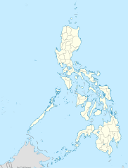
Deutsch: Positionskarte der Philippinen
Quadratische Plattkarte, N-S-Streckung 103 %. Geographische Begrenzung der Karte:
English: Location map of the Philippines
Equirectangular projection, N/S stretching 103 %. Geographic limits of the map:
|
| Datum | |
| Brón |
own work, using
|
| Sjriever | NordNordWest |
| Anger versies |
|


|
Deze kaart is gemaakt of verbeterd in de Duitse Kartenwerkstatt (Map Lab). Je kunt ook zelf kaarten ter verbetering voorstellen.
|
Licentie:
Ich, de kopierechhaajer hievan, bring 't hiebie óngere vólgendje lisensje oet:

|
Toesteumming wert verleend veur t kopiëre, verspreide en/of wiezige van dit document onger de veurwaerd van de GNU-licentie veur vrieje documentatie, versie 1.2 of einige latere versie es gepubliceerd door de Free Software Foundation; zonger Invariant Sections, zonger Front-Cover Texts, en zonger Back-Cover Texts. n kopie van de licentie is opgenomme in de sectie GNU-licentie veur vrieje documentatie. |
Dit bestandj steit gelicenseerdj óngere Creative Commons Attribution 3.0 Unported lisensje.
- De maags:
- deile – aafsjrieve, verspreie en dórchgaeve
- hèrminge – 't wèrk aanpasje
- Óngere volgendje veurwaerj:
- Attribuusje – Geer mótj op 'n gepasdje meneer 'n naamsvermeljing make, 'ne link nao de licentie opgaeve, en aangaeve of g'r 't werk verangerd höb. Geer moog dit op eder raejelike meneer doon, meh neet zoea det 't liek ofwen de licentiegaever instump mit eur werk of eur gebroek van zie werk.
De kens zelf de lisensje oetkeze.
Besjtandjshistorie
Klik op 'ne datum/tied om 't besjtand te zeen wie 't destieds waor.
| Datum/tied | Miniatuurplaetje | Aafmaetinge | Gebroeker | Opmirking | |
|---|---|---|---|---|---|
| hujig | 26 mie 2016 00:17 | | 1.871 × 2.468 (2,18 MB) | Man77 | upd NIR, Davao |
| 14 okt 2013 13:46 |  | 1.871 × 2.468 (2,2 MB) | Hariboneagle927 | fix | |
| 14 okt 2013 13:07 |  | 1.871 × 2.468 (2,15 MB) | Hariboneagle927 | fix. Cagayan | |
| 14 okt 2013 12:58 |  | 1.871 × 2.468 (2,15 MB) | Hariboneagle927 | Made some update and corrected some minor errors. | |
| 9 okt 2013 09:22 |  | 1.871 × 2.468 (2,14 MB) | Hellerick | Regrouped for easier recoloring. | |
| 7 aug 2013 08:13 |  | 1.871 × 2.468 (1,07 MB) | Hellerick | Regional division replaced with provincial division. | |
| 5 jul 2009 21:09 |  | 1.871 × 2.468 (1.009 kB) | NordNordWest | ||
| 25 mei 2009 23:04 |  | 1.687 × 2.469 (999 kB) | NordNordWest | {{Information |Description= {{de|Positionskarte der Philippinen}} Quadratische Plattkarte, N-S-Streckung 103 %. Geographische Begrenzung der Karte: * N: 21.2° N * S: 4.3° N * W: 115.4° O * O: 127.3° O {{en|Location map of the [[:en |
Bestandjsbroek
Gein inkel pagina gebroek dit plaetje.
Globaal besjtandjsgebroek
De volgende anger wiki's gebroeke dit bestandj:
- Gebroek in af.wikipedia.org
- Gebroek in als.wikipedia.org
- Gebroek in an.wikipedia.org
- Gebroek in az.wikipedia.org
- Gebroek in be-tarask.wikipedia.org
- Gebroek in be.wikipedia.org
- Gebroek in bn.wikipedia.org
- Gebroek in ce.wikipedia.org
- Gebroek in ckb.wikipedia.org
- Gebroek in crh.wikipedia.org
- Gebroek in cs.wikipedia.org
Bekiek wikiwied gebroek van dit bestandj.